Can You Actually Live Car-Free in Charlotte?
Charlotte neighborhoods you can live in without a car. Blue Line corridor, Uptown, South End, NoDa, with honest limits.

The honest answer to the car-free question
Our team often helps professionals locate walkable neighborhoods. Experiencing Charlotte without a car is entirely possible today. This lifestyle choice drastically cuts daily overhead costs.
We see many clients use those savings to secure prime real estate instead. AAA reported in 2025 that the average annual cost of owning a new vehicle reached $11,577. That $965 monthly expense could easily cover a commercial lease upgrade or mortgage premium.
Our analysts constantly monitor local transit metrics to find the best pedestrian zones. The city holds a baseline Walk Score of just 26. That number makes the broader metro area heavily car-dependent.
We designed this resource to clarify the exact realities of local transit. This guide covers several critical planning factors:
- Specific neighborhoods offer functional transit access.
- Our agents verify travel times along the rail corridor.
- Realistic limitations exist for suburban commuting.
- Financial advantages follow when downsizing vehicle ownership.
We tell every client that the realistic answer depends entirely on which specific street you choose.
Where car-free actually works
Three neighborhoods support genuinely car-free living in Charlotte: South End, Uptown, and the NoDa core. Each one has a different character and daily flow. We always point out that these three hubs provide the necessary infrastructure for a pedestrian lifestyle.
South End
South End serves as the densest car-free option in the city. The LYNX Blue Line spine runs from Bland through Scaleybark. Our clients love that this rail access puts most of the neighborhood within a 10-minute walk of a station.
Rail Trail pathways connect South End directly north into Uptown. Essential grocery stores like Publix and Common Market sit right within the neighborhood. We find the area ideal because gyms, dining, and craft brewery options all share the same blocks.
If you work Uptown and live anywhere in South End, transit fully covers the commute. High-density commercial developments here also mean fewer empty storefronts to walk past. We often show properties in this corridor to buyers who value a zero-commute lifestyle.
Uptown
Data from Walk Score gives the Fourth Ward area of Uptown an impressive 89 rating. This ranks it as the most walkable neighborhood in the entire city. Our team considers Uptown, especially the Fourth Ward and central core, highly livable because most daily needs sit within a 15-minute walk.
Major grocers like Reid’s Fine Foods and Harris Teeter Uptown serve the local residential towers. The Charlotte Mecklenburg Library main branch joins BoA Stadium and the Spectrum Center to provide excellent entertainment options. We appreciate how Blue Line stops directly connect everything else in the urban center.
The NoDa Core
The NoDa core features the smallest car-free footprint of the three. Centered around 36th Street and the Blue Line stations at Sugar Creek and 36th St, it maintains a highly localized feel. Our preferred aspect of NoDa is the dense concentration of the arts district, brewery scene, and walkable dining.
Residents gain easy Blue Line access to Uptown for work. Errands outside walking distance happen via transit or rideshare. We advise clients looking here to carefully map their daily routes before committing to a lease.
Where it gets hard
Plaza Midwood and Dilworth have highly walkable commercial cores but lack the transit gravity of the Blue Line corridor. Dilworth maintains a respectable 78 Walk Score, but accessing larger supermarkets often requires crossing major intersections. We see many homeowners in these areas rely on a hybrid approach for transportation.
You can live walkably for daily restaurants, coffee, and casual errands. Trips for bulky groceries, gym sessions, and weekend travel usually involve driving or rideshare. Our market data indicates most residents in these neighborhoods own a vehicle and use it two to three times per week.
Outside the five named neighborhoods, walkability drops sharply. York Road and similar outer districts often feature Walk Scores below 40. We remind business owners that placing an office in these outer zones will mandate parking solutions for employees.
Common hurdles in these transition zones complicate the pedestrian experience:
- Wide, multi-lane arterial roads frequently disrupt foot traffic.
- Our teams often map out workarounds for missing sidewalk connections.
- Distances of two or more miles to the nearest grocery store remain common.
- Limited protected bicycle lanes force riders onto busy streets.
We always advise checking the exact street layout before signing a commercial lease. University City provides Blue Line access, but the surrounding street pattern remains deeply suburban. You can handle a transit commute from there, but managing daily life requires a vehicle. Our relocation specialists highlight this distinction between a walkable commute and a walkable lifestyle.
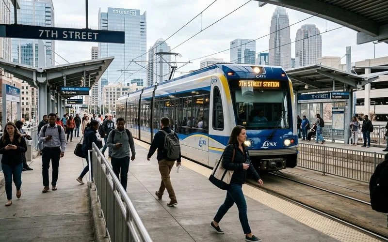
How the LYNX Blue Line actually works
The LYNX Blue Line operates as Charlotte’s primary light rail corridor. This system supports over 27,000 passenger trips every single day across its 26 stations. We rely heavily on this line to connect commercial clients with urban residential nodes.
The track runs 19.3 miles from UNC Charlotte in the north, through Uptown, to I-485 South. A standard one-way fare costs $2.20, providing an affordable alternative to downtown parking fees. Our property managers track travel times closely to help tenants plan their daily schedules.
| Departure Point | Destination | Average Travel Time |
|---|---|---|
| Uptown | South End | 10 to 15 minutes |
| Uptown | UNC Charlotte | 25 to 30 minutes |
| End-to-End | Entire Line | 50 minutes |
Travel time from end to end takes approximately 50 minutes. The trip from Uptown to South End requires just 10 to 15 minutes. We provide these baseline commute estimates because headways average 10 minutes during the weekday peak rushes.
Off-peak wait times stretch to 15 or 20 minutes, while weekend service runs every 20 to 30 minutes. Trains run roughly from 5:00 AM until midnight. Our teams remind newcomers that the Blue Line currently does not reach the airport.
Charlotte Douglas International sits about 15 to 20 minutes by car from Uptown. Travelers must plan accordingly for early flights. We suggest using a rideshare service as the most practical option for airport runs.
Rideshare and bike infrastructure
Uber and Lyft maintain high reliability across Uptown, South End, and Plaza Midwood. Pickup times in the urban core usually range from five to ten minutes. We tell clients to expect longer waits after midnight, especially in the outlying neighborhoods.
Electric scooter companies operate heavily in Uptown and South End, though vehicle availability fluctuates. Bike infrastructure has improved significantly through targeted city investments. Our urban planners closely follow the development of the $112.9 million Cross Charlotte Trail project.
This 30-plus-mile greenway network aims to connect Pineville through Center City up to UNC Charlotte. City data indicates the completed trail will place roughly 140,000 residents within walking distance of the path. We view this expanding network as a massive value booster for adjacent properties.
The bike-to-Uptown commute from South End or NoDa proves realistic and highly enjoyable in mild weather. Severe summer humidity and sporadic winter ice events frequently disrupt this comfortable routine. Our staff generally treats bicycle commuting as a fair-weather strategy rather than a year-round guarantee.
Experienced locals share a specific warning about the summer months. The intense heat index from June through August demands preparation. We frequently share this piece of advice with new arrivals:
“If you plan to bike commute during a North Carolina summer, ensure your office building offers secure bike storage and access to a shower facility. Showing up to a July morning meeting after a three-mile ride requires a change of clothes.”
Honest limits
We must be transparent about the geographical barriers in this region. Errands outside the Blue Line corridor frequently require a rideshare account or borrowing a vehicle. Weekend trips to Lake Norman, which sits 20 miles north, absolutely demand a car.
Our agents remind buyers that driving to the mountains in Asheville takes over two hours. Big-box shopping presents another major logistical hurdle. Reaching the IKEA at University Place means traveling roughly ten miles from the Uptown center.
We categorize these specific shopping runs as rental-car territory for anyone living completely car-free. Specific activities rapidly complicate a zero-vehicle routine:
- Transporting large pets to veterinary appointments proves difficult on trains.
- Our team members note that hauling bulk supplies from warehouse clubs requires ample trunk space.
- Managing weekend youth sports tournaments across different suburban counties demands a dedicated vehicle.
- Routine trips to hardware stores for home improvement projects test the limits of rideshare trunks.
We present these scenarios so you can evaluate your actual weekend habits. The realistic pattern involves scaling down to a single vehicle instead of owning two. Rideshare services and short-term rentals easily fill the gap of that second car. Our financial models confirm that dropping just one vehicle still saves a family over $11,500 annually.
Who should consider finding walkable neighborhoods: Charlotte without a car
Single professionals or couples without kids fit this profile perfectly. This lifestyle suits those working Uptown and living within a 10-minute walk of a Blue Line station. We highly recommend this approach for relocators coming from dense transit cities like Boston or Chicago.
Avoiding the sudden expense of restarting car ownership provides massive financial relief. Planners must recognize that work outside Uptown immediately changes the equation. Our consultants tell clients to plan for at least one vehicle if their household maintains multiple commute patterns.
The trade-off requires honest evaluation before you sign a long-term lease. Important factors to weigh demand your attention:
- Our agents remind buyers that daily commute distances to suburban offices dictate vehicle needs.
- Weekend travel habits heavily influence transportation budgets.
- Proximity to major grocery and retail hubs changes weekly logistics.
We emphasize that a clear understanding of these boundaries prevents costly real estate mistakes down the road. Comprehensive data on all regional transportation arteries assists your move. For deeper context on Charlotte commute patterns including I-77, I-485, and Blue Line specifics, see our Charlotte commute guide.
We know that careful planning makes living in the city highly rewarding. The right property matches your daily routine perfectly. Reach out today to schedule an initial consultation.
Common questions
What are the most walkable neighborhoods in Charlotte?
Is Uber and Lyft reliable in Charlotte?
Can I commute to work in Charlotte without a car?
Related guides
Best Time of Year to Move to Charlotte
Charlotte's seasonal weather, school calendars, and rental peaks. When to time your move for the best inventory and weather.
Charlotte Climate, Weather, and Seasonal Lifestyle
Charlotte's year-round climate, humidity, seasonal events, and outdoor rhythm. What to expect after a Northern move.
Charlotte Commute Guide: I-77, I-485, and the LYNX Blue Line
Real Charlotte commute reality on I-77, I-485, the toll lanes, and the LYNX Blue Line. Where to live based on commute, not zip code.
Charlotte vs. Raleigh: Which North Carolina City Fits You?
Charlotte vs Raleigh for relocators: industry mix, cost, climate, commute, lifestyle fit. Honest head-to-head comparison.
Ready to make Charlotte feel like home?
Free relocation match, typically same-week reply.